
Gavarda es un municipio perteneciente a la provincia de Valencia, en la comarca de la Ribera Alta. El término municipal está surcado por el río Júcar. Este río junto con la Acequia Real del Júcar rodean el pueblo. Tras sufrir una gran inundación en 1982, se decidió trasladar el pueblo a un lugar próximo más alto, y durante los años siguientes se construyó el nuevo asentamiento al que se trasladó la mayor parte de la gente, aunque algunas familias se resisten a abandonar el viejo pueblo. Este pueblo semiabandonado constituirá el área de proyecto.
Gavarda is a township located in the province of Valencia, in the region of Ribera Alta. The township is crossed by the river Júcar. This river along with the Acequia Real Júcar surround the village. After suffering a major flood in 1982, the town was moved to a nearby higher place, and during the following years most of the people moved to the new settlement, but some families are reluctant to leave the old town. This semi-abandoned village constitute the project area.
Plan Especial Gavarda Vieja
Este proyecto no entra únicamente dentro del campo del urbanismo, sino que también aborda cuestiones paisajísticas y sociales. El pueblo viejo de Gavarda es muy atractivo, incluso evocador, constituyendo un ámbito de proyecto interesante. Se aborda el trabajo desde la creencia en la posibilidad de regeneración urbana de esta población, que se llevaría a cabo mediante la puesta en valor del paisaje en el que se encuentra e implantando actividades relacionadas con la naturaleza. Además, se ha intentado fomentar el acercamiento entre la parte nueva y la antigua del pueblo, de tal forma que todo el municipio aprovecharía los beneficios que el proyecto reportase.
This project is not only within the field of urban planning, but also addresses landscape and social issues. The old town of Gavarda is very attractive even evocative, constituting an interesting field of project. Work is approached from the belief in the possibility of urban renewal of this population, which is carried out through the enhancement of the landscape in which it is located and implementing activities related to nature. The project tries to promote rapprochement between the new and the old village, so that the whole town would take advantage of the benefits that the project was reporting.
Fotografías del estado actual Gavarda antigua
Photos of the current state of old town of Gavarda

PLAN DE ACCIÓN TERRITORIAL DEL MÁRGEN IZQUIERDO DEL RÍO JÚCAR
URBAN PLANNING FOR THE LEFT BANK OF THE JUCAR RIVER
Dentro de la metodología de trabajo, primero se lleva a cabo un proyecto a escala territorial, en el que ya se muestra una voluntad de convertir a Gavarda en uno de los accesos a esta zona, siempre teniendo en cuenta que la puerta principal a este territorio es Alberique. Se piensa en Gavarda como un lugar al que acudiera y se pudiera alojar el turismo, actividad que podría llegar a ser uno de los pilares económicos de la zona. El turismo que se fomenta es rural, basado en el deporte y el contacto con la naturaleza, dado que tenemos muy cerca el macizo del Caroig y existen muchas rutas para hacer senderismo. De este modo, lo quese pretende es un cambio de movilidad en el territorio: de la movilidad basada en el vehículo privado a la movilidad no motorizada. Gavarda sería el punto en el que los turistas dejarían sus vehículos para recorrer la zona en bici o andando.
Within the working methodology, first is carried out a project on a territorial scale, which has a willingness to turn Gavarda into one of the entrances to the area shown, keeping in mind that the front door to this territory is Alberic. Gavarda is conceived as a place were the tourism would come and could accommodate. The tourism could become one of the economic pillars of the area, and is conceived as rural, based on sports and contact with nature, as we are near to the massif Caroig and there are many hiking trails. Thus, it is intended a change in the mobility of the territory: from a mobility based on private vehicle to a non-motorized mobility. Gavarda would be the point where tourists leave their cars for touring the area by bike or on foot.
PLAN DIRECTOR DE GAVARDA VIEJA
URBAN PLANNING FOR THE OLD TOWN OF GAVARDA

 PLAN DIRECTOR |  USOS DEL ESPACIO PÚBLICOUSES OF PUBLIC SPACES |  PROGRAMA DE USOSUSES PROGRAM |
|---|
Dentro del suelo con uso terciario, se propone la implantación de pabellones para la Universidad Politécnica de Valencia, que tendría allí una residencia temporal que se llevaría a cabo con contenedores marítimos reciclados. También se implanta una escuela.
Se proyectan dos hoteles y un cámping. Con estos equipamientos pretendemos que los turistas que estén acostumbrados a vivir en la ciudad se acerquen a Gavarda para tener un contacto con el mundo rural. Además, implantamos un centro de actividades náuticas junto a la Acequia Real del Júcar.
Por último, se rehabilitan dos edificaciones ya existentes en el municipio para convertirlos en centro cultural y edificio para la universidad. El primero se llevará a cabo en unas naves ganaderas ya existentes, y el segundo, en la escuela de jardinería existente en Gavarda vieja, en desuso por no haber suficiente demanda.
Within the ground with tertiary use, the proposal consists on the implantation of pavilions for the Polytechnic University of Valencia, which would have there a temporary residence that would be done with recycled shipping containers. A school is also implanted.
The project includes also two hotels and a campsite. With these facilities we claim that tourists who are used to living in the city come to Gavarda to have contact with the rural world. A water sports center is implemented beside the Acequia Real del Júcar.
Finally, two existing buildings are rehabilitated to become cultural center building for the university. The first will take place on the already existing livestock buildings, and the second, in the gardening school that already exists, disused because of insufficient demand.
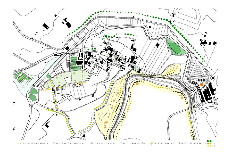
PROYECTO PARA LA VEGETACIÓN
VEGETATION PROJECT


INFOGRAFÍAS
RENDERINGS
Sección realizada por la zona de nuevo crecimiento residencial. Se observa la eliminación de la carretera, que suponía una barrera entre el río y la acequia, reforzando así su relación y los recorridos peatonales. La carretera aparece en las traseras de las viviendas. Una pasarela permite conectar el barrio residencial con la otra orilla del río, de tal manera que se atenúa el efecto barrera del mismo. También aparece una edificación perteneciente al patrimonio hidrográfico de la Acequia Real del Júcar. En la propuesta, se realiza un acceso desde la pasarela, de este modo se pondría en valor el patrimonio hidrográfico.
Estado actual
Estado proyectado
Section done by the area of new residential growth. It is observed the removal of the road, which was a barrier between the river and the canal, thereby strengthening their relationship and the pedestrian routes. The road appears on the rear of the houses. A walkway connects the suburb to the other side of the river, so the barrier effect is attenuated. A building belonging to the hydrographic heritage of the canal Acequia Real del Júcar also appears. In the proposal, there is an access from the gateway, thus the hydrographic heritage is assessed.
 ESTADO ACTUAL |  PROYECTO PABELLONES UNIVERSIDAD |
|---|
 ESTADO ACTUAL |  PROYECTO ROTONDA ACCESO GAVARDAProject of roundabout for the access to Gavarda |
|---|